MARIKINA FAULT LINE
Disclaimer: Data used to support this article were obtained from geologic reports made available through the Internet. Special credit goes to Mr. Tulisanes and his maps at Exposing the Marikina Valley Faultline System. His maps were of great help in locating the actual fault line. With his permission, the maps were elaborately "superimposed" on modern Google Earth maps that show details of streets and buildings. Although the fault line was carefully extrapolated, some errors may persist. The author does not
attest that the specified locations point to the EXACT LOCATION OF THE
FAULT, which may lie in any area about 100 meters to the east or west of
the specified location. Such contention does not negate the FACT that a
FAULT LINE DOES EXIST, and should merit attention for the safety of the
general public.
The Marikina Fault Line, as depicted in this article, is a dextral strike-slip fault that extends from Montalban, Rizal (north end) and runs through the cities of Marikina, Makati, Pasig and Taguig. The fault line terminates near Carlos P. Garcia Avenue at Taguig City.


If we follow the path of the fault starting from the northern end, we shall start at Mount Balagbag (Montalban); then pass some 1 mile to the east of Macabud Elementary School, and a half-mile to the west of Montalban Islamic Cemetery. The fault almost runs parallel to Mayon Avenue (Montalban), lying some 300 meters to the west of Erap Paaralang Pantao at Montalban Hills. Still following Mayon Avenue, the fault goes farther southward at the middle of Villa Ana Maria Subdivision and Kasiglahan Village. The fault hugs the Payatas Road traversing south-south-west and lies about 500 meters to the east of Parkwoods Village and about 1000 meters to the west of Dela Costa Homes V.


Then the fault traverses barren land, lying some 1000 meters away to the east of Payatas Landfill until it hits residential area near the intersection of Spring Country Avenue and James Street near San Mateo River. Still traversing south-south-west, the fault intersects Titus Road and sharply veers southwest to Bagong Silangan passing the streets of Bonifacio and Alejandro in-between Mascardo and Macabulos streets, about 100 meters west of Jeronimo Park.

At Bagong Silangan, the fault touches the north-west tails of M. H. del Pilar, Evangelista, Francisco, De Dios, and Arellano streets as it dips farther south-south-west, before hitting the eastern tail of Byron street.

The fault traverses farther south-south-west along grassy land and almost hugs the entire length of Byron street, from a distance of about 350 meters from Filinvest 2 Park. Then it hits the intersection of Day and Dodge streets before crossing the streets of Davis, Dona Justina, Crane, and Cohen. Then it intersects Batasan-San Mateo Road farther south-west, about 150 meters away from Gold Park.
A second fault line can be seen on the map. It also intersects Cohen but lies midway between Tatiana and Neptune streets near Sunnyside Village, before intersecting Milky Way Street and Batasan-San Mateo Road. Farther south-west, the fault hits a residential area of small houses.

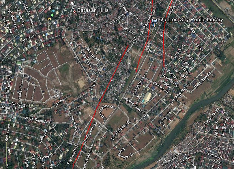
Near Batasan Hills, our first fault line hugs Ambe Street some 40 meters to the west and traverses a path about 100 meters from the Quezon City Public Library, before intersecting Turquoise Street. The fault terminates at the eastern end of Moscow Street farther south.
The second fault line intersects Tamate Street and passes 30 meters to the west of Quezon City Public Library. It also intersects Turquoise Street before terminating at the intersection of Belfast Street and Katipunan Extension.
Now we begin to see the emergence of another fault line which starts near Morado Street, Batasan Hills and traverses south-west until it hits the intersection of Montreal and Plymouth Streets. The fault continues south-west intersecting Delhi Street and almost hugs Panama Street 10 meters to the west.

The main fault line continues its south-west traverse hugging Katipunan Extension some 30 meters to the west, and hitting its intersection with London Avenue, about 50 meters east of Harvard Home Stay. The fault then passes through farm land and reaches Barangay Tumana farther south. It crosses Moscow Street before terminating near Nova Scotia.

At Bagong Silangan, the fault touches the north-west tails of M. H. del Pilar, Evangelista, Francisco, De Dios, and Arellano streets as it dips farther south-south-west, before hitting the eastern tail of Byron street.

The fault traverses farther south-south-west along grassy land and almost hugs the entire length of Byron street, from a distance of about 350 meters from Filinvest 2 Park. Then it hits the intersection of Day and Dodge streets before crossing the streets of Davis, Dona Justina, Crane, and Cohen. Then it intersects Batasan-San Mateo Road farther south-west, about 150 meters away from Gold Park.
A second fault line can be seen on the map. It also intersects Cohen but lies midway between Tatiana and Neptune streets near Sunnyside Village, before intersecting Milky Way Street and Batasan-San Mateo Road. Farther south-west, the fault hits a residential area of small houses.

The second fault line intersects Tamate Street and passes 30 meters to the west of Quezon City Public Library. It also intersects Turquoise Street before terminating at the intersection of Belfast Street and Katipunan Extension.
Now we begin to see the emergence of another fault line which starts near Morado Street, Batasan Hills and traverses south-west until it hits the intersection of Montreal and Plymouth Streets. The fault continues south-west intersecting Delhi Street and almost hugs Panama Street 10 meters to the west.
The main fault line continues its south-west traverse hugging Katipunan Extension some 30 meters to the west, and hitting its intersection with London Avenue, about 50 meters east of Harvard Home Stay. The fault then passes through farm land and reaches Barangay Tumana farther south. It crosses Moscow Street before terminating near Nova Scotia.
Another fault line emerges 200 meters to the west. It begins at the farm land and crosses the streets of Moscow, Denmark, Katipunan, and Finland.


The fault continues its south-west traverse despite discontinuities in the line. It runs almost parallel to Katipunan Road; first traversing 150 meters east of Katipunan, terminates, and continues at the eastern end of Rome Street and crosses Soliven Avenue and Katipunan Extension. It hugs Soliven Avenue 15 meters to the west, crosses Spain Street and Bilaan Drive and terminates at Honduras Street.

From Honduras Street, the fault continues its south-west traverse, partly hugging the northern part of Paraguay Street and crossing Hon. B. Soliven Avenue II. The fault then goes parallel to Columbia Street 260 meters east of Ateneo de Manila High School, 230 meters from the Jesuit Residence, and 210 meters from the University Dormitories.
Another fault lies parallel 50 meters to the east, which starts at the southern end of Paraguay Street and continues south-west, partially hitting the north-western portion of St. Ignatius de Loyola Memorial Park.

Another fault lies parallel 50 meters to the east, which starts at the southern end of Paraguay Street and continues south-west, partially hitting the north-western portion of St. Ignatius de Loyola Memorial Park.

Three faults now dissect Barangay Barangka of Marikina City. The fault at the left (nearest to Columbia Street) intersects Mother Theresa Street and enters the Ateneo University compound. It lies 30 meters east of Loyola House of Studies and intersects St. Ignatius Street before terminating at Seminary Road.
The middle fault intersects St. Joseph Avenue and bisects San Jose Seminary almost at the middle. It intersects Iglesia Ni Cristo Street and terminates at F. Tuazon Road.
The right fault starts at the northern end of Don Gonzalo Puyat Street and crosses Cenera Julian Cruz Street hitting several houses in Dela Costa Homes along the way. The fault lies just 10 meters away from Barangka Elementary School before intersecting A. Bonfacio Avenue farther south-west.

After crossing A. Bonifacio Avenue, the fault intersects M. Cruz, M. Gonzales, and Joseph streets some 130 meters away from Riverbanks Center, Marikina City. It then crosses Marcos Highway and passes near the intersection of Apitong and Lauan Streets. Afterwards, it intersects the streets of Kamagong, President Osmena, President Magsaysay, and Jose Santos. At this point, the fault lies about 80 meters west of Our Lady of Nativity Parish. Continuing its south-west traverse, the fault enters Barangay Industrial Valley Complex intersecting the streets of Santos Dixon, President Aguinaldo, President Quezon, President Roxas, Taurus, Aquarius, Cancer, Scorpio, and Capricorn.


Entering Blue Ridge B Subdivision, the fault passes Starine Road and shares a common intersection with Evening Glow Road and Riverside Drive. It crosses FVR Road farther south and so enters Libis, Quezon City. It passes through the western part of Camp Atienza and then intersects the southern tail of Riverside Drive. It passes by Eastwood City until it hits the intersection of Mercury Avenue and Eulogio Rodriguez Avenue. Crossing the street, the fault dips slightly south-east and enters St. Ignatius Village hugging almost the entire length of Titan Street. At this point, the fault lies about 500 meters away from Camp Aguinaldo.

Returning to its south-west traverse, the fault hits the intersection of Titan and Poseidon Streets, enters White Plains Subdivision as it runs parallel to Whitefield Avenue about 60 meters to the east. It hugs almost the entire length of Cecilleville Street until it intersects Adonis Street farther south. After crossing Green Meadow Avenue, the fault intersects Swallow Drive, Flamingo Street, and almost hits the intersection of Nightingale and Sparrow Streets. At this point the fault is about 460 meters away from Christ the King Church.
Continuing its south-west traverse, the fault intersects Swallow Drive, Dove Street, and runs almost parallel to Green Meadows Avenue 50 meters to the east. It passes by the intersection of Bee and Butterfly Streets about 15 meters to the west and hits the intersection of Butterfly and Beetle Streets farther south. It then crosses Firefly Street and Ortigas Avenue.

The fault crosses Celery Drive and almost hits the intersection of Cabbage and Cucumber Streets. Then it passes by Mustard Street and Celery Drive (again) before intersecting Dona Julia Vargas Avenue farther south. Afterwards, it hugs part of Lanuza Avenue. Crossing the street, the fault sharply veers to the south-west intersecting Narra and Malipajo Streets.

Entering Barangay Ugong, Pasig City, the fault crosses the streets of St. Martin, Sineguelas, Pina, Melon, Mabolo, Duhat, Chico, and Balimbing, where it lies about 300 meters to the east of Philippine Sports Complex (Pasig ULTRA) and about 250 meters from Valle Verde Country Club. Then the fault crosses Canley Road farther south, and dissects an area between Escarpment Road and Banner Street.

As the fault enters Bagong Ilog, Pasig City it diverges into two. One fault closely hugs Kagandahan Street to the west, and crosses Kabutihan Street and Eugenio Meja Road. The other fault intersects Kasayahan Street to the east. The latter fault intersects Kapayapaan Street and Eugenio Meja Road before rejoining the first fault near Pasig Boulevard.

The fault hugs Carlos P. Garcia Avenue about 40 meters to the east, and about 250 meters from Napindan Floodgate. Upon reaching the other bank, the fault intersects Dr. Jose P. Rizal Extension, P. Urduja and P. Zamora streets, and crosses 4th, 5th, 6th, 7th, 8th, 9th, and 10th avenues before reaching M. Concepcion Avenue farther south. After which, it consecutively intersects 12th, 13th, 15th, 16th, 17th, and 18th avenues upon reaching East Rembo. At this area, the fault lies 200 meters to the east of West Rembo Elementary School and 90 meters to the west of East Rembo Elementary School.

The fault nips Mother Dolorosa Church as it passes 19th and 20th Avenues. It continues its south-west traverse as it crosses 21th, 22nd, 23rd, 24th, 27th, 25th, 28th, 29th before intersecting Amapola Street farther south. At this area, the fault is about 170 meters away from the Church of Jesus Christ of Latter Day Saints. Continuing its traverse, the fault crosses the streets of Bouganvilla, Camia, Dahlia, Escarlata, Gumamela, and Jasmin. At this area, the fault lies just 25 meters away from Pembo Elementary School.

At Pembo, the fault crosses the streets of Ilang-Ilang, Kampupot, Las Maras, Mirasol, Orkidia, Rosas, Zenia, and Tarhata, bisecting these streets half-way between Cadena de Amor and Sampaguita Streets. It intersects Azucena and Lower Azucena further south. It crosses Sampaguita Street about 15 meters away from its intersection with Amarillo Street. At this place the fault lies about 100 meters from the nearby Iglesia ni Cristo Church.

At Taguig City, the fault passes near the intersection of Sampaguita Extension and Begonia Street, about 30 meters to the east of Fort Bonifacio Seventh Day Adventist Church. Traversing farther south-west, the fault intersects the streets of Catleya, Dona Aurora, Ivory, Gladiola, Blueberry, and Blue Vos. Then it goes across Carlos P. Garcia Avenue.

Traversing farther south-west, the fault crosses Commando Road and Scorpion Street before hugging almost the entire length of Abbot Street. It hits the intersection of Abbot and Centuar Streets, and crosses the streets of Fox, Hombe, Firefly, Challenger, Matilda, General Dado, Apitong, Bakawang, Chico, and Durian. The fault terminates at a place near the eastern end of Durian Street. At this place, the fault is about 70 meters west of Carlos P. Garcia Avenue and about 140 meters west of BCDA Compound.


6 comments:
Sir, where and how did you download the geomap with fault tracings?
Sir, where and how did you download the geomap with fault tracings?
Dear readers, I obtained may geo maps from Mr. Tulisanes (not his real name) at his website Exposing the Marikina Valley Fault System. With his permission, I used his maps and "superimposed" them on modern Google Earth maps. Please read my disclaimer found at the beginning of this article. Jun Fuderanan, author.
Your maps are very helpful, Mr. Fuderanan. Thank you very much!
YES I LIVE ON THE FAULT IN MALIPAJO
Where would the safest place be in Metro Manila should an earthquake emanating from the WVF strike? Thank you.
Post a Comment